Sunday, August 18, 2019

Hiking: Kessler Peak

Last Saturday, August 10, a few of us from our church hiker's group headed up Big Cottonwood Canyon in the Wasatch Mountains to try hiking a peak I've never hiked before. Kessler Peak is easily visible to anyone traveling the canyon. Near Donut Falls and just across the ridge from Mineral Fork, and across two ridges from Lake Blanche, it's a prominent point in the Wasatch. Visible also from Mt. Raymond and Gobblers Knob, it reaches to 10,403 feet in elevation, which is higher than both Raymond and Gobblers across the way.
The trail begins off of the same trailhead that goes to Donut Falls. It's rated as difficult and main challenge is a 2,874 foot elevation gain in about 2.2 miles. That's according to alltrails.com. We measured the distance at just over 5 miles. It's very steep.
Much of the trail is in the shade, which is a plus considering the extreme exertion you are under when climbing it. Trekking poles are recommended, especially on the way down. Once at the top you will be rewarded with amazing views of Broad's Fork Twin Peaks, Dromedary, Mt. Superior, Mt. Raymond, Gobblers Knob, and the backside of Mt. Olympus. You can even find Sundial Peak if you know where to look.


Getting there:

From the bottom of Big Cottonwood, drive up about 8.9 miles to where there is a large parking lot along the road on both sides. On the right is the turn off for the Donut Falls trailhead. There is often parking available right at the trailhead, so it's worth taking a look, especially early in the day. The trailhead is about .8 miles on this side road. Girl on a Hike has a good description of how to find the actual trail here: Clickety-click

Trip Report

Three of us began this hike. Myself, Robert, and Luke. I being the oldest, age 60,  began huffing and puffing from the beginning. I had asked some folks previously if  this hike was as tough (meaning steep) as the really steep part of the Jacob's Ladder route to Lone Peak. I was having a hard time making myself understood as to just exactly where I meant. I found this hike to be not quite as steep as that, but steep enough to keep me stopping to catch my breath, especially as we gained elevation.
Part way up we saw an old miner's cabin and just past it, a mine that went back in a ways. I hadn't brought my flashlight or headlamp along and the small cell phone lights were ineffective at showing how far back the mine went in. If I ever do this hike again, I'll bring one. On the way down, we met some guys who were familiar with the area and they told us there was one place where there's a tunnel all the way through the mountain. There may be a cave troll there though, so beware.
What remains of an old cabin near an abandoned mine.

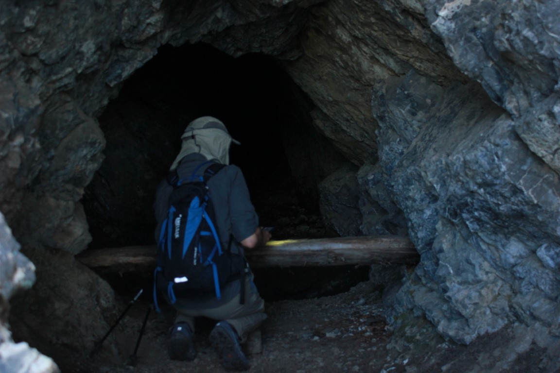
Robert examines the mine.
Soon after we passed the cabin and mine, there was a pretty long stretch of extremely steep trail. After that, we were near the top and zig-zagged around rocks picking our way up. No scrambling was involved, but it was terrain that required watching where you put your feet.
Once on top the views were amazing. I sat down and ate a Clif Bar then took a few pics. Soon it was time to go down.
Robert checking out the views with  Dromedary Peak and Broad's Fork Twin Peaks visible.

Toward Little Cottonwood and Mt. Superior

Luke and Robert checking pics and maps


The upper Cardiff area above Donut Falls

Mt Raymond and Gobblers Knob to the north.


The backside of Mt. Olympus and the Salt Lake Valley

Dromedary and Twins

The steepness on the way down was tough too. I was glad I had the poles as they saved me from falling on my rear end a time or two.
As we ended, Robert, who at 51 is a very experienced hiker who gets out frequently, commented that even his calves had begun burning. As for me, my calves had given me trouble on the way up, and my quads on the way down. For me, I'd rate the difficulty as pretty extreme. The good news is, stepping up my workouts to prepare for steep hikes kept me from having severe muscle pain a day or two later. Sure, I ached a bit, but not like I normally do. I really do recommend if you can't actually get out and hike a lot, that your gym workout include step climbers and treadmills with increasingly steep angles. And some plyometrics are helpful too. Preparing yourself to do hikes like this is part of having a great adventure.

Sunday, August 11, 2019

Mineral Fork: a return to the past

Years ago, there was a place called "Mineral Fork" high in the Wasatch Mountains, in Big Cottonwood Canyon. Actually it's still there, but years ago, you could drive up in it in four-wheel drive vehicles. It wasn't easy. There were some waterfall crossings that were pretty intense back then. We went up there once in the 1970s in my friend's FJ40 Toyota Landcruiser ( I later owned one, and I have missed having it ever since I got rid of it in the early 80s). All of us were teenagers out for a fun four-wheeling experience.
My friend's Landcruiser was a lot like this except baby blue.
We drove up to a mine that I later found out was called the Wasatch Mine. People had been here before us, long ago, working in the side of the mountain, looking for precious metals. That road may have been started by them--or maybe it existed even further back and was some kind of Native American trail, or even a game trail in places. Now, while it's still open to ATVs and is the only place in Big Cottonwood that allows that, it is a great place to take a hike. No ATVs were up there this day, and if they were, they would've had a challenging time getting past a tree that had fallen across the trail. I have heard that before long ATV access will no longer exist up here.
The reason being is partially because not many people hike here. They find other more popular destinations, like Lake Blanche, Desolation Lake, and nearby peaks, like Mt. Raymond and Gobblers Knob.
I knew this. I had been up this trail several times since the four-wheeling days in the seventies. The first time was soon after that time. I hiked up in there. I think I was still a teen, but maybe I was 20. Anyway, I was young and dumb and failed to pack water. There is a stream up there that comes right out of the mine, turning the rocks orange. The water is contaminated, but I didn't know that then. I was mad with thirst and bent down to drink out of the stream. I didn't feel all that good afterward, but I didn't die. Although maybe, if I get cancer sometime in my life, it will end up being because I put that contamination in my body way back when. You never know.
This past Wednesday, I had been planning a hike with my son Ben, who was going to take me to breakfast and then hike with me as a birthday present. My birthday had been a few weeks ago, but we had scheduled the hike for my staycation week. The night before, Ben ended up having car problems and had to take his car to the mechanic. He wanted to be available if they called him, so he had to cancel (and hopefully reschedule) the hiking portion. We still went out to breakfast and after that I drove up to the "trailhead". Wanting to still do the original hike with Ben, I had decided to do Mineral Fork instead of our original plan, which was to hike the Alexander Basin trail to Gobblers Knob.
There is no sign at the beginning of  the Mineral Fork trail. At least not right at the roadside. All I can say is that it's above the S-curve, but before you get to Mill D, and it's a gate on the right side of the road. Hike back in there, cross the stream, and you'll see a sign there identifying it as Mineral Fork, about fifty yards in.
I began hiking at 9 am. There was only one other vehicle parked near the gate. I had no idea if whoever was in the car had gone up the Mineral Fork trail, or maybe had used it as access to fish Big Cottonwood Creek, or something else.
These waterfalls are just above the road
The trail is fairly steep and switchbacks back and forth across the stream a couple of times before finally making its way back into the canyon.  It's mostly through wooded areas, so there's protection from the sun for a large portion of the trail. This particular day, was overcast, so there was more sun protection, and less opportunity to get any great pics. In addition to the steepness, there's a lot of loose rock on the trail. I had a time deadline, so I thought I'd hike up until about 11:00 and then turn around. I knew that I'd be taking a bunch of pics, which would slow me down, so I had no idea if I'd make it to the Wasatch Mine, which was three miles back in. My goal would be to get beyond that and up to the Regulator Johnson Mine, which is another two miles, and then up to the ridge, to look down into Lake Blanche and over to Sundial Peak.
I made it to the mine just at 11:00 and took a few pics. The history of mining in these mountains was evident throughout the upper canyon. Definitely interesting for the history buff as well as the hiker.
It had begun sprinkling, so I tucked my camera away in my pack and headed down. I found some wildflowers that I had to try and get some good photos of though, and the camera came back out. The rain still hadn't


Wasatch mine tailings and wildflowers
intensified, so I left the camera out.
When I was maybe 2 miles back down, a guy came up behind me and passed me. I assumed he was the owner of the other vehicle I had seen down below. That's the only person I saw on the trail.
It's a Beautiful hike with many possible picnic sites and places to rest. If I would've begun earlier, I could've made it to the other mine and possibly the ridge. I will have to keep that in mind for future adventures.

Looking up at the Wasatch Mine and upper Mineral Fork


The Wasatch Mine